The City of Unley is planning cycling and walking improvements for Stages 2 and 3 of the Young Street Neighbourhood Bicycle Route, and we want your feedback!
This project is part of our Walking and Cycling Plan 2022-2027, which prioritises creating safe and accessible routes for pedestrians and cyclists.
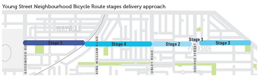
The Young Street Neighbourhood Bicycle Route is a key east-west walking and cycling route connecting:
- To the east: City of Burnside and Glen Osmond Road.
- To the west: Wayville Showgrounds, Goodwood business precinct and the Mike Turtur Bikeway.
Young Street also provides important local connections to the Parkside Primary School, Parkside Childcare, St Raphael’s School and North Unley Park.
What’s happening?
- Stage 1 (intersection of George Street and Young Street) was recently upgraded for improved safety and accessibility for pedestrians and cyclists.
- Stages 2 and 3 (between Unley Road and Glen Osmond Road) will build on these improvements and encourage more walking and cycling in the Parkside area.
The proposed concept design plans for Stages 2 and 3 of the Young Street Neighbourhood Bicycle Route can be found in the Concept Design Report.
A visual animation of the concept design for Stage 3 between George Street and Glen Osmond Road can be found here.
The key features of Stage 2 concept design between Unley Road and George Steet include:
- Installation of four new on-street landscaped kerb buildouts on south side of street between Porter Street and George Street.
- Approximately 11m² of additional greening, with space for up to four new trees (subject to the feasibility of underground services).
- Installation of 10 new street print locations featuring road markings (or bicycle symbols) to improve route navigation.
- Minimal parking impact to achieve the proposed plan – the loss of one on-street parking space (0.1% reduction to overall parking capacity).
The key features of Stage 3 concept design between Unley Road and Glen Osmond Road include:
- Installation of five new single-lane slow points with a speed hump, bicycle bypass and landscaping to improve cyclist safety and traffic calming.
- Installation of four new printed pavement treatments at intersections along the street corridor to enhance visibility and navigation.
- Installation of a 65m shared-use path on the northern side of Young Street near the Glen Osmond Road approach, to provide a safe connection for pedestrians and cyclists to the signalised crossing point.
- Approximately 110m² of greening opportunities, with the potential for planting up to 5 new trees (subject to the feasibility of underground services).
- Loss of 18 on-street parking spaces (representing a 12% reduction in parking capacity) to enable the broader benefits of the plan to be realised.
How to provide feedback
We’d love to hear your thoughts on the proposed improvements.
- Review the Young Street Neighbourhood Bicycle Route (Stages 2 and 3) Concept Design Report.
- View a display on the proposed improvement at McLeay Park on Saturday 3 May 2025 between 10 -11am and Wednesday 7 May 2025 between 5.15 - 6.15pm. Project staff will be present to help answer your questions.
- Complete the survey below.
If you would like further information, please contact the Transport Team on 8372 5111 or email pobox1@unley.sa.gov.au.
Hard copies of the survey are available from the Unley Civic Centre (181 Unley Road) during business hours.
What happens next
Your views are important to us. Your feedback will help us refine the concept designs before seeking Council endorsement in 2025. When approved, the project is expected to move into the detailed design phase in the 2025-2026 financial year.


